Article
Open Access
Assessing the low-carbon potential of magnesium silicate hydrate cement: a probabilistic life cycle approach
Yue LiXiao LuoXiaolong LiuZhijie ZhangKun MengJinlei Mu

DOI:10.55092/sc20250012

Received

26 Feb 2025

Accepted

27 Apr 2025

Published

16 May 2025
PDF
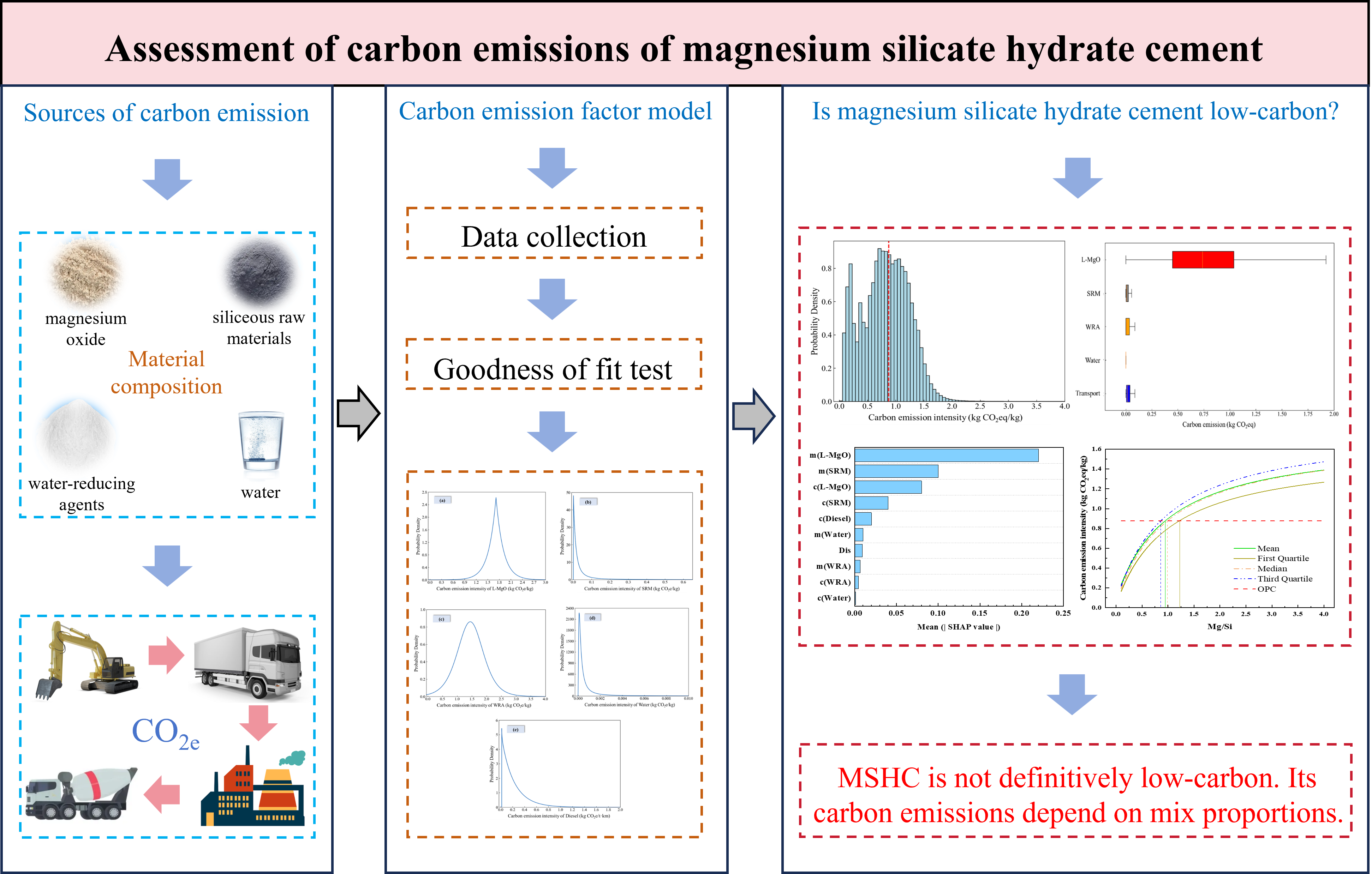
Magnesium silicate hydrate cement (MSHC), as an innovative low-carbon cementitious material, is considered a potential substitute for ordinary Portland cement (OPC). However, uncertainties in the carbon emission factors of raw materials and mix proportions pose challenges for assessing its life cycle carbon emissions. This study employs a probabilistic life cycle assessment (PLCA) to evaluate the carbon emission intensity of MSHC and analyze its uncertainties. Leveraging machine learning techniques, a predictive model for the carbon emission intensity of MSHC was developed, and sensitivity analysis was conducted on various characteristic parameters. The results indicate that although MSHC is regarded as a low-carbon material, it does not exhibit low-carbon characteristics in all scenarios compared to OPC. The carbon emission intensity of MSHC is closely related to its mix proportions. Depending on different mix proportions, the average carbon emissions of MSHC range from 0.174 to 1.419 kg CO2e/kg. L-MgO is a key factor influencing the uncertainty of MSHC carbon emissions. Notably, the Mg/Si ratio is a critical factor influencing the carbon emission characteristics of MSHC, with a low-carbon threshold range observed between approximately 0.8 and 1.0.
Correction
Open Access
Correction to: Monitoring of ground and building settlements induced by tunneling based on terrestrial LiDAR data: a case study in Singapore
Xinchen ZhangJiajun LiSiau Chen ChianQian Wang

DOI:10.55092/sc20250011

Received

14 Apr 2025

Accepted

08 May 2025

Published

14 May 2025
PDF
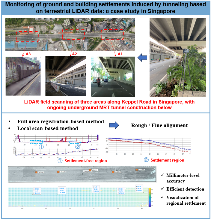
Ground and building settlements induced by tunneling excavation are common in cities. Such settlements can cause instability of the ground and threaten the safety of the upper infrastructures or buildings. Hence, it is vital to monitor the settlements during tunnel excavation to identify any potential risk. The current approach for settlement monitoring relies on manual measurements, which suffers from low efficiency and high labor cost. To improve monitoring efficiency, this study presents a settlement monitoring method based on terrestrial LiDAR data, which mainly consists of rough and fine alignment steps. Algorithms are developed to automatically process the 3D point cloud data obtained from terrestrial LiDAR and obtain settlement values for grounds and buildings. The proposed technique was applied and validated in a region with on-going tunneling works in Singapore. Different monitoring strategies including local-scan based method and registration-based method were examined and compared in this case study. Results demonstrated that the local scan-based monitoring method could yield more accurate settlement measurements compared with the traditional survey method. Registration-based method had higher calculation efficiency but with insufficient accuracy. In general, it is demonstrated that the LiDAR based settlement monitoring method is feasible in engineering practice, with measurement errors controlled within 2–3 mm, and has great potential to improve efficiency and reduce labor cost required by the traditional method.
Article
Open Access
Effects of environmental factors on robotic building processes: a physical experimental investigation
Cheav Por CheaYu BaiYihai Fang Elahe Abdi

DOI:10.55092/sc20250010

Received

29 Jan 2025

Accepted

22 Apr 2025

Published

06 May 2025
PDF
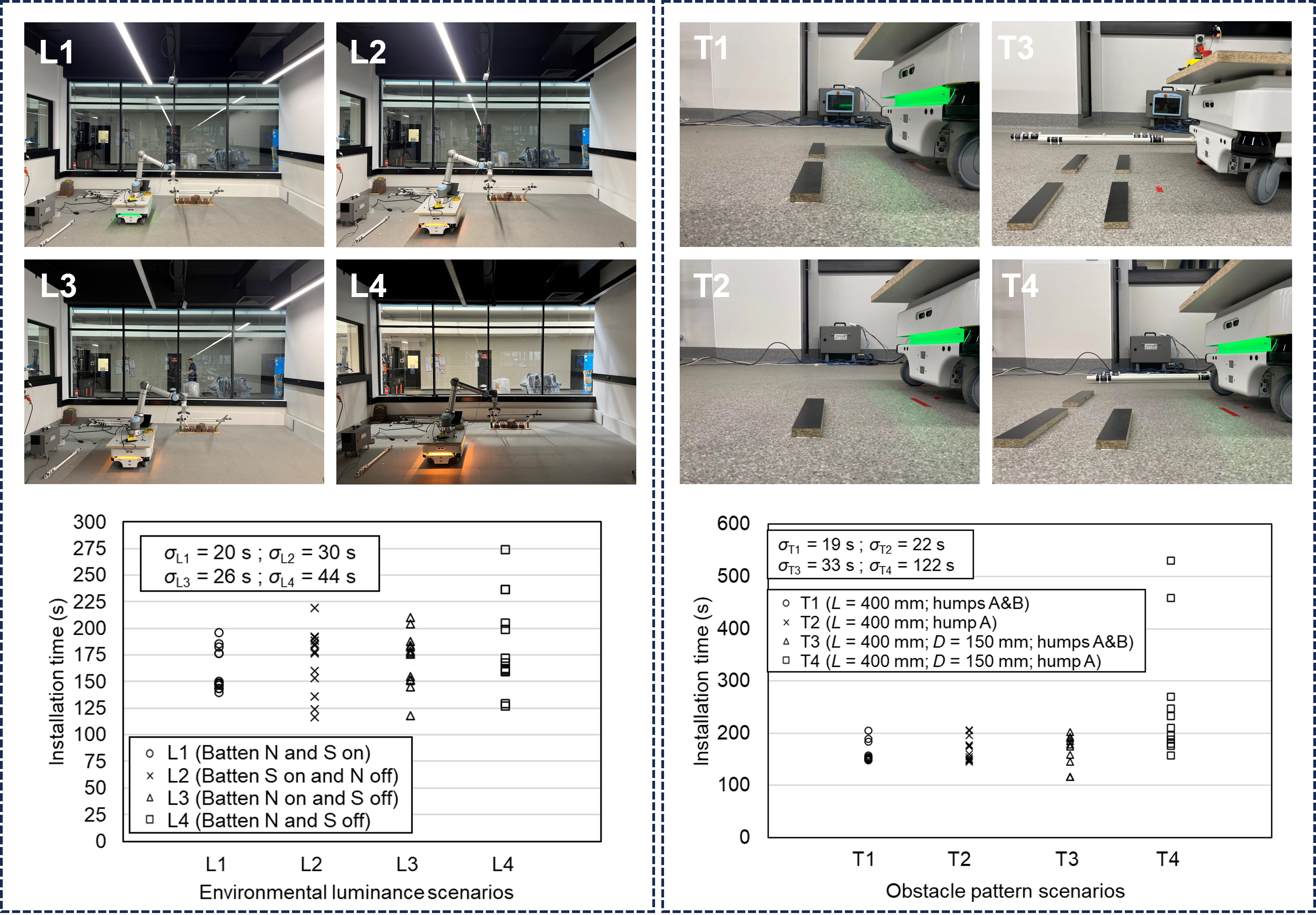
As robotic applications in building processes increase, the majority of studies focus on development of algorithms for object targeting, path planning, and localisation. Very limited attention is given to environmental factors, such as varying luminance and presence of undetected obstacles, that are common on construction sites and can significantly influence the robotic system performance. To address the gap, this work investigates the effects of environmental conditions on robot performance in structural assembly. A series of physical experiments was conducted in a laboratory setting to evaluate the effects of different lighting conditions on the positional accuracy of the robotic arm, the time required to install components, and the overall successful rate of the robotic assembly. The coordinates and orientations of installed AprilTag markers, captured by a red green blue-depth (RGB-D) camera, were then analysed to determine the effects of luminance levels on the accuracy of the positioning robotic system in two different assembly tasks. Furthermore, under constant luminance conditions, obstacles were arranged in various patterns along the path of a mobile robot to evaluate changes in trajectory and alignment disturbances. Differences in robot orientation, installation times, and completion status of the assembly tasks were also recorded to understand the impact of obstacle configurations on the efficiency and adaptability of the robotic system in structural assembly.
Extended Conference Paper
Open Access
GIS based solutions for management of public building and infrastructure assets: a review of state of the art and research trend analysis
Pavel PopovM. Hamed MozaffariSeyedReza RazaviAlaviFarzad Jalaei

DOI:10.55092/sc20250009

Received

27 Jan 2025

Accepted

07 Apr 2025

Published

30 Apr 2025
PDF
Building asset management is a complex endeavor that involves development, operation, maintenance and disposal of large-scale costly assets that serve one or more significant functions. Recent and continuing developments in Geographical Information Systems (GIS) offer solutions to the significant challenges of integrating and visualizing asset management data, choosing development proposals, cost assessment, risk assessment and maintenance strategies. Furthermore, GIS data is a common element among many types of projects, buildings and infrastructure assets. GIS technologies can therefore have a significant and broad impact. Navigating GIS developments can be difficult and unclear. To this end, this study performs a literature review on state-of-the-art and emerging GIS technologies as they apply to public asset management. The aim is to provide public authorities with a means to understand the potential and the challenges of these GIS technologies in order to support more informed decision making. The main opportunities that these technologies provide to AM are examined. These include data integration, optimization of resource use, risk assessment and improved decision making from reactive to proactive. In addition, a new Word2Vec K-means based keyword gap analysis tool is proposed to aid in the visualization of keywords in the literature corpus by sorting the keywords into meaningful subject focused categories. This study will help make adoption choices of GIS technologies more informed and coherent, which will allow the reduction benefits in costs, energy and environmental impacts to be more easily leveraged.
Article
Open Access
Knowledge-based intelligence method for controlling segment floating by optimizing shield tail grouting parameters
Gan WangQian FangJun WangGuoli ZhengQiming LiJianying Wei

DOI:10.55092/sc20250008

Received

29 Nov 2024

Accepted

09 Apr 2025

Published

29 Apr 2025
PDF
Extensive segment floating will result in segment dislocation, crack, and leakage, posing significant risks of engineering accidents. It is important to control the segment floating based on adjusting shield operational parameters finely. A knowledge-based intelligence method designed for controlling segment floating is proposed in this study. Leveraging prior knowledge in segment floating, the framework of the intelligence method is constructed. This framework consists of a segment floating prediction model along with two auxiliary models. The segment floating prediction model considers the spatial and temporal characteristics of the shield operational parameters, including the early activation of the shield excavation parameters and the hysteretic nature of tail grouting parameters. The segment floating prediction model is the basis of the knowledge-based intelligence method. A multi-ring optimization strategy is designed to solve the conflict between the optimization results of adjacent rings. The case study shows that the segment floating prediction model has high prediction accuracy due to consideration of the spatial and temporal characteristics of the shield operational parameters. Considering the performance and computation cost, the optimal parameter configuration is figured out.
Article
Open Access
Numerical investigation of seismic performance and size effect in CFRP-reinforced concrete shear walls
Bo LiDong LiFengjuan ChenLiu JinXiuli Du

DOI:10.55092/sc20250007

Received

31 Dec 2024

Accepted

27 Mar 2025

Published

18 Apr 2025
PDF
Addressing conventional reinforced concrete (RC) shear walls’ susceptibility to brittle failure and residual deformation during earthquakes; this study investigates carbon fiber reinforced polymer (CFRP)-RC composites for enhanced seismic resilience. CFRP’s superior strength-to-weight ratio; corrosion resistance; and self-centering potential address post-earthquake reparability challenges. Current knowledge gaps persist in size-effect mechanisms under combined geometric and reinforcement parameters (shear span ratio; horizontal reinforcement ratio; height-to-thickness ratio). Numerical analysis of 28 models evaluates hysteretic behavior; strength degradation patterns; ductility coefficients; and residual deformation characteristics. A refined size-effect model incorporating CFRP’s strain distribution overcomes existing predictive limitations; advancing performance-based design of damage-tolerant structures.